


No Fly Zone
คำอธิบายของNo Fly Zone
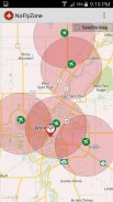
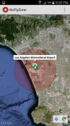
This app contains over 46,000 airports around the world which can be displayed quickly and easily when flying RC models. When flying RC/UAV's commercially, these areas are considered "No Fly Zones" based on your geographic location.
For example when flying UAV's in Canada, Transport Canada has set a 9km no fly zone around Airports without proper legal authorization.
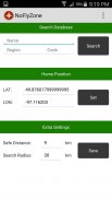
By default this app sets a 9km radius around Airports and will display all airports within 30km of your marker.
These settings can be adjusted depending on geographic location and rules in your area.</div> <div jsname="WJz9Hc" style="display:none">app นี้มีมากกว่า 46,000 สนามบินทั่วโลกซึ่งสามารถแสดงผลได้อย่างรวดเร็วและง่ายดายเมื่อบินรุ่น RC เมื่อบิน RC / UAV ในเชิงพาณิชย์ของพื้นที่เหล่านี้ได้รับการพิจารณา "ไม่มีโซนบิน" ตามสถานที่ตั้งทางภูมิศาสตร์ของคุณ
ตัวอย่างเช่นเมื่อในการบิน UAV ของแคนาดาขนส่งแคนาดาได้มีการกำหนด 9 กมไม่มีโซนบินไปรอบ ๆ สนามบินโดยไม่ต้องอนุมัติกฎหมายที่เหมาะสม
โดยค่าเริ่มต้น app นี้ชุดรัศมี 9 กมรอบสนามบินและจะแสดงทั้งหมดที่อยู่ภายในสนามบิน 30 กมเครื่องหมายของคุณ
การตั้งค่าเหล่านี้สามารถปรับขึ้นอยู่กับที่ตั้งทางภูมิศาสตร์และกฎระเบียบในพื้นที่ของคุณ</div> <div class="show-more-end">
No Fly Zone--เวอร์ชั่น3.0
(22-04-2016)No Fly Zone - ข้อมูล APK
เวอร์ชั่น APK: 3.0แพ็คเกจ: com.reelmedia.NoFlyZoneเวอร์ชั่นล่าสุดของNo Fly Zone


แอปในประเภทเดียวกัน


คุณอาจจะชอบ...


